From the National Hurricane Center:
On the forecast track, Helene will move across the eastern Gulf of Mexico today and cross the Florida Big Bend coast this evening. After landfall, Helene is expected to
turn northwestward and slow down over the Tennessee Valley on Friday and Saturday.
Maximum sustained winds are near 85 mph (140 km/h) with higher gusts. Strengthening is forecast, and Helene is expected to be a major hurricane when it reaches the Florida Big Bend coast this evening. Weakening is expected after landfall, but Helene's fast forward speed will allow strong, damaging winds, especially in gusts, to penetrate well inland across the southeastern United
States, including over the higher terrain of the southern
Appalachians.
HAZARDS AFFECTING LAND
----------------------
Key Messages for Helene can be found in the Tropical Cyclone
Discussion under AWIPS header MIATCDAT4 and WMO header WTNT44 KNHC and on the web at hurricanes.gov/text/MIATCDAT4.shtml
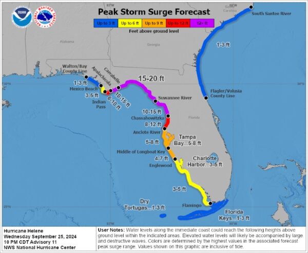
STORM SURGE: The combination of a life-threatening storm surge and the tide will cause normally dry areas near the coast to be flooded by rising waters moving inland from the shoreline. The water could reach the following heights above ground somewhere in the indicated areas if the peak surge occurs at the time of high tide...
Carrabelle, FL to Suwannee River, FL...15-20 ft
Apalachicola, FL to Carrabelle, FL...10-15 ft
Suwannee River, FL to Chassahowitzka, FL...10-15 ft
Chassahowitzka, FL to Anclote River, FL...8-12 ft
Indian Pass, FL to Apalachicola, FL...6-10 ft
Anclote River, FL to Middle of Longboat Key, FL...5-8 ft
Tampa Bay...5-8 ft
Middle of Longboat Key, FL to Englewood, FL...4-7 ft
East of Mexico Beach, FL to Indian Pass, FL...3-5 ft
Englewood, FL to Flamingo, FL...3-5 ft
Charlotte Harbor...3-5 ft
For a complete depiction of areas at risk of storm surge inundation, please see the National Weather Service Peak Storm Surge Graphic,available at hurricanes.gov/graphics_at4.shtml?peakSurge.
Storm surge could raise water levels by as much as 2 to 4 feet above normal tide levels in areas of onshore winds along the southern coast of Pinar del Rio, Cuba, including the Isle of Youth.
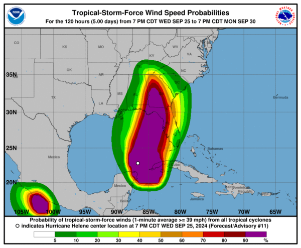
WIND: Hurricane conditions are expected within the U.S. hurricane warning area late today, with tropical storm conditions beginning this morning. Tropical storm conditions are expected in southern Florida this morning and will spread northward across the rest of Florida, Georgia, and South Carolina through tonight.
Tropical storm conditions are expected over portions of the warning area in western Cuba during the next several hours.
RAINFALL: Hurricane Helene is expected to produce total rain
accumulations of 4 to 8 inches over western Cuba, the Cayman Islands and the northeast Yucatan Peninsula, with isolated totals around 12 inches. This rainfall brings a risk of considerable flooding.
Over portions of the Southeastern U.S. into the Southern
Appalachians, Helene is expected to produce total rain accumulations of 6 to 12 inches with isolated totals around 18 inches. This rainfall will likely result in catastrophic and potentially life-threatening flash and urban flooding, along with significant river flooding. Numerous landslides are expected in steep terrain across the southern Appalachians.
For a complete depiction of forecast rainfall associated with Hurricane Helene, please see the National Weather Service Storm Total Rainfall Graphic, available at
hurricanes.gov/graphics_at4.shtml?rainqpf and the Flash Flood Risk graphic at hurricanes.gov/graphics_at4.shtml?ero.
TORNADOES: A tornado or two may occur this morning over parts of Florida. The risk for tornadoes will increase later today, expanding northward across Florida into parts of Georgia and South Carolina.
SURF: Swells generated by Helene will affect the southern coast of Cuba and the Yucatan Peninsula of Mexico during the next couple of days. Swells will spread northward toward the west coast of Florida and the northeastern Gulf Coast today. These swells are likely to cause life-threatening surf and rip current conditions. Please consult products from your local weather office.

MARBERO Portable Power Station 88.8Wh Solar Generator 150W P...
$68.99 (as of May 20, 2025 16:03 GMT -04:00 - More infoProduct prices and availability are accurate as of the date/time indicated and are subject to change. Any price and availability information displayed on [relevant Amazon Site(s), as applicable] at the time of purchase will apply to the purchase of this product.)
Jackery Explorer 300 Plus Portable Power Station, 288Wh Back...
$219.00 (as of May 20, 2025 16:03 GMT -04:00 - More infoProduct prices and availability are accurate as of the date/time indicated and are subject to change. Any price and availability information displayed on [relevant Amazon Site(s), as applicable] at the time of purchase will apply to the purchase of this product.)
Anker SOLIX C300 DC Power Bank Station, Outdoor 288Wh Portab...
$189.99 (as of May 20, 2025 16:03 GMT -04:00 - More infoProduct prices and availability are accurate as of the date/time indicated and are subject to change. Any price and availability information displayed on [relevant Amazon Site(s), as applicable] at the time of purchase will apply to the purchase of this product.)
200W Power Inverter for Dewalt 20V, DC 20V to AC 110-120V Ba...
$37.99 (as of May 20, 2025 16:03 GMT -04:00 - More infoProduct prices and availability are accurate as of the date/time indicated and are subject to change. Any price and availability information displayed on [relevant Amazon Site(s), as applicable] at the time of purchase will apply to the purchase of this product.)
Anker SOLIX C1000 Portable Power Station, 1800W (Peak 2400W)...
$448.99 (as of May 20, 2025 16:03 GMT -04:00 - More infoProduct prices and availability are accurate as of the date/time indicated and are subject to change. Any price and availability information displayed on [relevant Amazon Site(s), as applicable] at the time of purchase will apply to the purchase of this product.)